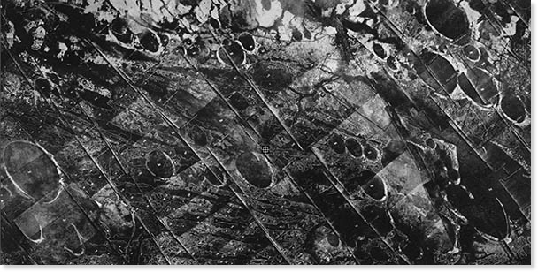
Please note that all “bayCarolina” archetype bays, such as these, display an interesting emplacement artifact. The ejecta droplet involved arrived from the upper left (NNw) in this image. The ejection site is therefore to the north of the emplacement site. The droplet's velocity has a west-to-east vector component that includes the Earths west-to-East rotation velocity at the ejection site’s latitude, but the Earth’s surface in Myrtle Beach (lower latitude) is moving west-to-east at a higher velocity. As a result, the entire emplacement is effectively compressed on the western (left) side. This creates a structure that is not symmetrical across the major axis. This artifact offers for another correlation between an emplaced object and the physics of transporting it to the emplacement site.
Carolina bays are elliptical depressions concentrated along the Atlantic seaboard within coastal Delaware, Maryland, New Jersey, North Carolina, South Carolina, Virginia, Georgia, and north-central Florida (Prouty 1952, Kaczorowski 1977). In Maryland, they are called Maryland basins (Rasmussen and Slaughter 1955). Other landform depressions, not widely accepted as Carolina bays, are found within the northern Gulf of Mexico coastal plain within southeast Mississippi and Alabama where they are known as either Grady ponds or Citronella ponds.
For further visual exploration, the reader is referred to George A. Howard's web site, which offers a wonderful set of arial photographs of Carolina bays.
Carolina bays Interpreted as Depositional Artifacts in a Veneer of Ejecta
While interpretation of the Carolina bays sands as distal ejecta structures would be controversial due to its dependence on a truly massive deposition of ejecta, the creation of the stylized Carolina bay geometry can easily be seen in the simple paint splatter.
Others have probed and researched the bays and their contents, but those investigations have always considered that the bays were formed within or excised from a hosting strata of sand or gravel which itself was created by well-understood fluvial and eolian deposition. In our interpretation, the region was overlain by a 1 to 50 meter thick "sheet" of ejecta slurry from the Saginaw impact ~800,000 years ago. The bays are a surface feature of that veneer of strata. This interpretation helps to explain the creation of bays seen at significantly varying elevation while being quite close to each other, often even overlaying each other. Also explained is a mechanism that could create bays, which exist on hilltops; the hills themselves being composed of emplaced ejecta. This is our interpretation of the structure know as the Goldsboro Ridge in NC.
The Saginaw Impact Manifold Depositional Conjecture holds that a sheet of ejecta debris -a slurry of water and sand/silica - was deposited across a pair of "butterfly" arcs extending our from each side of the impact. The sheet exhibits a surface texture of "splatter" marks, which have evolved into today's Carolina bays.
We emphasize that our conjecture does NOT suggest that the bays are either primary or secondary impact structures.
The geomorphic signatures seen in these structures are many, and no other deposition method has been implicated satisfactorily. Arriving from the upper left in these images, the sheet of debris slammed into the terrain, and spread across areas of varying elevation. Within a few hundreds of meters, we see Carolina bays created at significantly different elevations - up to 50 meters variation - as well as having them overlaid and/or partially obscured by additional material arriving moments later. With an incoming velocity of 3,000 km/hour, the slurry surged forward at impact and crated slightly higher rims on the SE end of the splash bay. The ground speed difference effect driven by the latitude delta between the Saginaw ejection point and the deposition location would have added an west-to-east velocity component of hundreds of m/sec. This component would be expected to distort the surficial bay features along the E-W axis, which has been reported:
"Many bays, however, lack true bilateral symmetry along either the major or minor axis. ….the northeast side bulges slightly more than the southwest side. (1)
Other supportive details include the well-understood fact that, universally, the soil layers containing the bays are superimposed on underlying strata at a sharp and "abrupt comfortable" interface that shows no inter-beding. Much of the current research identifies the strata as consistent across wide areas, both within single and multiple bays.No variation in the heavy mineral suite was found along a traverse of the major axis of one South Carolina bay; even though samples were taken from the bay floor, bay rim and the adjacent non-bay terrace. (Preston and Brown, 1964).
When presented with the ejecta strata concept in 2006, noted soil geologist R.B. Daniels observed that the conjecture, while hard to embrace, did address one ongoing enigma of the bays (and Goldsboro Ridge in particular): The unconsolidated deposits that constituted the rim bays did not contain the lenses of clay that would be expected in a classical fluvial deposition mechanisms.We created an initial catalogue of ~170 "Fields" of Carolina bay structures. Using the facilities of Google Earth, these sites have been analyzed heuristically to test for geographic association with the proposed Michigan area impacts. In our opinion, the alignment is highly supportive of the conjecture. Subsequent to the initial “field” survey prior to 2010, a more extensive ongoing survey is being conducted and has catalogued over 45,000 individual bay structures to date. See Carolina Bay Survey.