Carolina bay Planforms
A primary corollary of the MPT Impact hypothesis is that the Carolina bays robustly conform to ovoid planforms; so robustly that they simply can not be 'wind & wave', and are therefore derivative of a catastrophic event. We offer a focused web tool that allows the visualization of Carolina bay planforms using a "before-after" technique to allow the user to roll on and off our bayCarolina archetype planform, so the viewer can assess the fit with their own eyes. But I encourage you to look; many geologist have informed me they refuse to look because they already have a belief system that demands they are not catastrophic in nature. The tool is mobile-aware, and can (on most browsers) enter a full-screen mode to enable even higher resolution viewing. Each bay is presented in a normalized orientation (horizontal) and size (~ 2/3 of screen) to remove those biases. Enter the tool directly using this LINK. For information about the tool, a navigation menu is available. The information page for the tool is available directly using this LINK. The facility was presented at the 2019 GSA Southeastern meeting (LINK).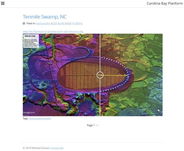
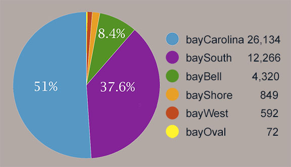
The Survey employs six archetypical planform overlays to facilitate measurement of the bays [3]. Each is created as a PNG file and rendered in Google Earth as an image overlay, which is manually place over a given bay’s imagery (satellite or DEM) and adjusted for major & minor axis and orientation. When it is deemed a good match to the 2D planform, the overlay’s KML text is processed to yield (with a bit of trig) the subject bay’s metrics, and the on-line Fusion database is updated. The overlay KML is also saved as a discrete file on our servers, so that it can be easily recovered onto the Google Earth virtual globe and checked for accuracy. Pie graph below shows bay distribution by type.
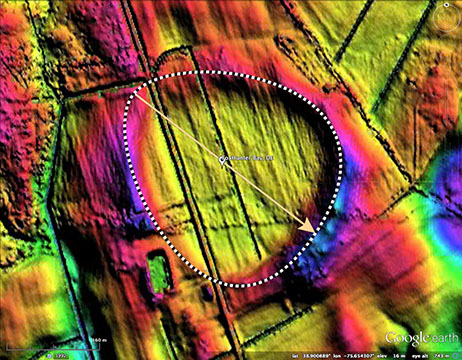
The archetypes are shown in below, in order of appearance along the proposed MPT Impact ejecta annulus from New York to Nebraska, demonstrating the statistical variation seen in their orientations. The example archetype LiDAR images are hyperlinked for access to our Google + “Carolina bay of the Day” (CBoD) posts surveyed with the respective archetype shape. The base CBoD blog URL is http://cbotd.cintos.org . These posts were originally published on the Google + social media site, but were moved because it is being shut down in the fall of 2019.
bayBell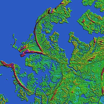
bayOval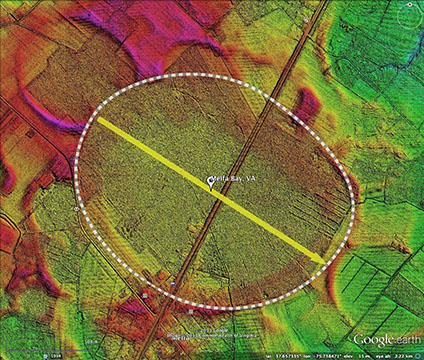
bayShore
bayCarolina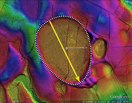
baySouth
bayWest
The recognition of the existence of "Carolina bays" was driven by their distinct and persistent geometric planforms and their sheer numbers, in combination with sharing a common alignment in any one area. The visual photography available since the identification in the 1930's only told a part of the story.
With the availability of today's LiDAR (Laser Imaging and Range Detection) systems, the true extent and planforms of these enigmatic landforms are brought to life in a stunning manner. Interpreting these ovoid landforms as being derivatives of well-understood wind and water-shaped dunes cannot be supported by evidence of similar processes elsewhere in the world.
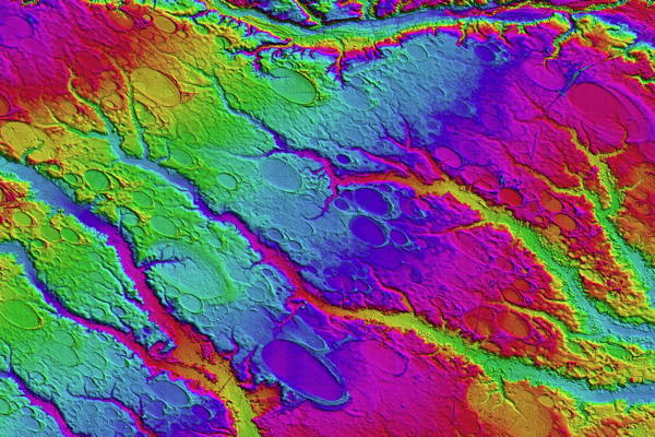
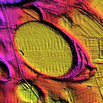
Carolina bays surrounding Rex, NC area - click for higher resolution image
The Color-Ramp shading of the above LiDAR-derived image (USGS Datum) demonstrates on of the most commonly overlooked characteristics of the bays: the blanket is continuous across the pre-existing terrain, and the bays show no differential based on emplacement elevation. The above view covers ~ 600 square kilometers, and significant elevation changes.
The primary planform seen as a bay in this discussion is the oval. Their characteristics have been reviewed extensively by other workers. Most prominent, we feel, are the sharply defined closed ridge which surrounds the structure, the persistent repetition of a common shape within a locale, the common alignment of those shapes, a predisposition to possess a higher, thicker ridge on one of the major axis ends of the shape, and finally the vast diversity of sizes they are generated in. Dune fields often generate structures with some of these characteristics, but never all of them simultaneously.
Numerous studies have examined the bays' planforms. Most extensive was Douglas Johnson's work, as presented in his book "The Origin of the Carolina Bays", Volume IV of Columbia University's , Columba Geomorphic Studies series. His examination of bays, both in person and in aerial photographs, noted three planforms: The elliptical/oval, egg shaped elliptical/ovoid, and random. In the ovoid form, we see a simple development of the down-range tip of the bay, where it narrows more than in other bays, although we do see the "narrowing" concept at work in the vast majority of bays.
Johnson offered a drawing in his book that includes references to both Oval and Ovoid, along with measured bearings for a variety of ares.
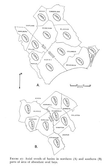
Oval and Ovid bays. Linked to higher resolution image
Here is a pen drawing included by Johnson, which details his understanding of how bays are included in the coarse sand stratum as depressions, without causing observable distortion to the stratum, which would be expected from a direct impact and excavation scenario. See extracts from the book discussion this aspect in the Origins_Book Section.
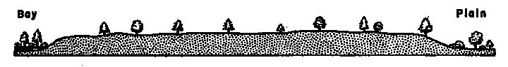
FIGURE 18: Typical cross profile of sandy rim from inner side next bay to outer side bordering plain. Vertical scale greatly exaggerated.
Altitude of broad flat-topped rim usually varying from 2 or 3 up to 5 or 6 feet; breadth from 150 to 800 feet or more.
Two other drawings are available, both of which demonstrate the same inclusion principal. First, in R.B. Daniel's drawing of bays formed within the Goldsboro Ridge, followed by the cross-section provided from the Midlothian bays. We see these three depictions as supporting our ejecta blanket hypothesis, where the bay depressions are imperfections in the surface of the blanket created during emplacement. The entire bulk of the sand stratum in which the bays are contained is considered to be ejecta.

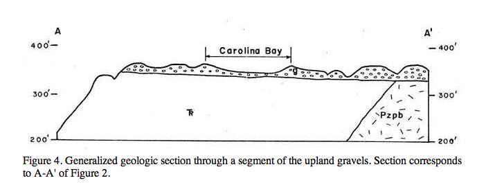
from Guidebook To The Geology Of The Upland Gravels Near Midlothian, Virginia By Bruce K. Goodwin and Gerald H. Johnson
With the availability of today's LiDAR (Laser Imaging and Range Detection) systems, the true extent and planforms of these enigmatic landforms are brought to life in a stunning manner. Interpreting these ovoid landforms as being derivatives of well-understood wind and water-shaped dunes cannot be supported by evidence of similar processes elsewhere in the world.

Carolina bays surrounding Rex, NC area - click for higher resolution image
The Color-Ramp shading of the above LiDAR-derived image (USGS Datum) demonstrates on of the most commonly overlooked characteristics of the bays: the blanket is continuous across the pre-existing terrain, and the bays show no differential based on emplacement elevation. The above view covers ~ 600 square kilometers, and significant elevation changes.
The primary planform seen as a bay in this discussion is the oval. Their characteristics have been reviewed extensively by other workers. Most prominent, we feel, are the sharply defined closed ridge which surrounds the structure, the persistent repetition of a common shape within a locale, the common alignment of those shapes, a predisposition to possess a higher, thicker ridge on one of the major axis ends of the shape, and finally the vast diversity of sizes they are generated in. Dune fields often generate structures with some of these characteristics, but never all of them simultaneously.
Numerous studies have examined the bays' planforms. Most extensive was Douglas Johnson's work, as presented in his book "The Origin of the Carolina Bays", Volume IV of Columbia University's , Columba Geomorphic Studies series. His examination of bays, both in person and in aerial photographs, noted three planforms: The elliptical/oval, egg shaped elliptical/ovoid, and random. In the ovoid form, we see a simple development of the down-range tip of the bay, where it narrows more than in other bays, although we do see the "narrowing" concept at work in the vast majority of bays.
Johnson offered a drawing in his book that includes references to both Oval and Ovoid, along with measured bearings for a variety of ares.

Oval and Ovid bays. Linked to higher resolution image
Here is a pen drawing included by Johnson, which details his understanding of how bays are included in the coarse sand stratum as depressions, without causing observable distortion to the stratum, which would be expected from a direct impact and excavation scenario. See extracts from the book discussion this aspect in the Origins_Book Section.
FIGURE 18: Typical cross profile of sandy rim from inner side next bay to outer side bordering plain. Vertical scale greatly exaggerated.
Altitude of broad flat-topped rim usually varying from 2 or 3 up to 5 or 6 feet; breadth from 150 to 800 feet or more.
Two other drawings are available, both of which demonstrate the same inclusion principal. First, in R.B. Daniel's drawing of bays formed within the Goldsboro Ridge, followed by the cross-section provided from the Midlothian bays. We see these three depictions as supporting our ejecta blanket hypothesis, where the bay depressions are imperfections in the surface of the blanket created during emplacement. The entire bulk of the sand stratum in which the bays are contained is considered to be ejecta.
from Guidebook To The Geology Of The Upland Gravels Near Midlothian, Virginia By Bruce K. Goodwin and Gerald H. Johnson